Officials won’t lift evacuations for 188,000 as flood danger around Calif. dam eases
Daily News Article — Posted on February 14, 2017
(by Eliott C. McLaughlin and Paul Vercammen, CNN) — [At least 188,000 people will have to stay away from their homes as crews work to calm the potential flood danger around a dam’s troubled emergency spillway in northern California Monday, emergency officials said.]
The residents, mostly in Butte, Sutter and Yuba counties, evacuated from the area, some being given only minutes to gather their things.
“Everyone was running around; it was pure chaos,” Oroville resident Maggie Cabral told CNN affiliate KFSN on Sunday. “All of the streets were immediately packed with cars, people in my neighborhood grabbing what they could and running out the door and leaving. I mean, even here in Chico, there’s just traffic everywhere.”
The area had long been in drought until this year when heavy rain and snow bombarded the state. In Oroville, the average annual rainfall is about 31 inches, but since October, the Feather River, which begins at Lake Oroville, had already seen 25 inches of rain as of Saturday, according to the California Department of Water Resources [DWR].
The lake also gets water from the northern Sierra Nevada mountain range, which is experiencing one of its wettest seasons.
…No rain is predicted until Wednesday. [And as of Monday], efforts to lower the water level on Lake Oroville appeared successful, a DWR official said.
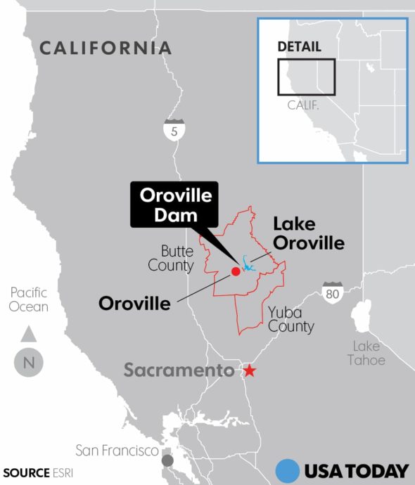
Oroville Dam is the country’s tallest, and the emergency spillway that’s eroding had never been used in the 48 years that the dam has existed, the DWR says. The closest Lake Oroville came to topping the emergency spillway was in January 1997, when the lake level rose to within a foot of flowing over it.
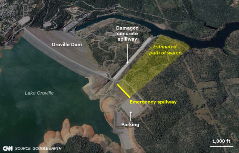
The Oroville Dam provides flood control for the region. The dam has two spillways to release water out of the lake to prevent overflow. Both have problems.
In the main spillway, which is…paved, erosion has caused a hole almost the size of a football field and at least 40-feet deep to form in the lower part of the channel. It can’t be fixed immediately. …
The emergency spillway, which is an embankment covered with trees, is a last resort and was used for the first time in history on Saturday when the lake topped 901 feet, its capacity, and a light flow of water washed into the spillway.
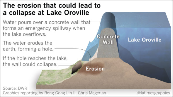
Around 3 p.m. (6 p.m. ET) Sunday, authorities [discovered] that the emergency spillway was also eroding, Butte County Sheriff Kony Honea said.
DWR and CAL FIRE crews quickly began clearing the brush, trees and rocks to limit the amount of debris washing into the lake’s diversion pool and the Feather River. …
The erosion of the emergency spillway is dangerous because “when you start to erode the ground, the dirt and everything else starts to roll off the hill,” said Kevin Lawson, a CAL FIRE incident commander. “It starts to undermine itself. If that is not addressed, if that’s not mitigated properly, essentially what we’re looking at is approximately a 30-foot wall of water.”
…On Sunday afternoon, Sheriff Honea’s office issued a dire warning, employing the most urgent of language — “This is NOT a drill” — in imploring residents to evacuate. At the time, officials said the spillway was in danger of failing any minute.
The evacuation order included “all Yuba County on the valley floor” and the city of Marysville, authorities said.
About 35,000 people from Butte County, 65,000 from Yuba County, 76,000 from Yuba City and 12,000 from Marysville City evacuated, according to CAL FIRE.
The DWR instructed Oroville residents to head north, toward Chico.
Conversely, the Yuba County Office of Emergency Services warned its residents, “Take only routes to the east, south, or west. DO NOT TRAVEL NORTH TOWARD OROVILLE!!!!!”
The Sacramento Fire Department echoed the urgency and warned residents that the spillway failure could have effects, including flash flooding, 75 miles downstream in Sacramento.
Stores closed. Shelters opened. Police manned roadblocks. Evacuees waited in traffic trying to escape low-lying areas. Residents mobbed gas stations on their way out of town. By early Monday, many of the pumps at those gas stations had yellow tape across them, indicating they were out of gas.
Sean Dennis, who lives 30 miles south of Oroville, spoke to CNN from his car after spending 4½ hours in heavy traffic.
“It was pretty scary, just because of how fast everything was developing,” he said. “Me and my wife managed to throw as much stuff as we could into garbage bags, whatever we could find. We got both of our cars loaded down pretty well. We’re not taking any chances.”
The urgency later subsided, with authorities reporting that the situation was not as desperate as previously thought. Still, Sheriff Honea said he wasn’t taking any chances.
“I’m not going to lift the evacuation order until I have a better idea of what that means and what risk that poses,” he said late Sunday night.
…After issuing the evacuation orders, authorities noted significant decreases in the water coming over the emergency spillway.
The flow of water on the emergency spillway eventually stopped Sunday night as the DWR withdrew more water from the other spillway. …
As of 8 a.m. Monday (11 a.m. ET), Lake Oroville had dropped to 897.2 feet, about 4 feet below capacity, said DWR spokesman Eric See. It continues to drop at a rate of about 4 inches an hour, he said.
“We want to drop that water level before the next storm hits Wednesday,” Doug Carlson, Spokesman for DWR told CNN earlier. “It’s supposed to be a colder storm, which is good. Last week the rain storm was warmer. So we had both the rain runoff and the warmer rain melting the snow and that snow melt also flowed into the lake.”
CNN’s Eliott C. McLaughlin reported and wrote from Atlanta. CNN’s Paul Vercammen reported from Oroville. CNN’s Madison Park, Sheena Jones, Chuck Johnston, Azadeh Ansari and Carma Hassan contributed to this report.
Reprinted here for educational purposes only. May not be reproduced on other websites without permission from CNN. For the original article, visit CNN.com.
Background
NOTE: Lake Oroville is the largest reservoir in the California State Water Project, a network of canals and pumping stations that move water from Northern California to the Central Valley and Southern California. It’s one of the key reservoirs in the system that stores water for the dry spring and summer months.
The LA Times reported on Monday:
- The Department of Water Resources acting director told reporters Monday (Feb. 13) that he was "not familiar with 2005 documentation or conversation" surrounding potential spillway problems at Lake Oroville.
- Speaking at a 12:30 p.m. press conference, acting DWR director Bill Croyle was asked to comment on calls more than 10 years ago to establish a concrete channel for the dam's emergency spillway.
- Although the dam facility's main spillway is paved with concrete, the emergency spillway is not. Erosion that occurred along the emergency spillway over the weekend prompted the evacuation of more than 100,000 people late Sunday.
OROVILLE DAM
- Oroville Dam is an earthfill embankment dam on the Feather River east of the city of Oroville, California.
- At 770 feet high, it is the tallest dam in the U.S. and serves mainly for water supply, hydroelectricity generation and flood control.
- The dam impounds Lake Oroville, the second largest man-made lake in the state of California, capable of storing more than 3.5 million acre-feet (4.4 km3), and is located in the Sierra Nevada foothills east of the Sacramento Valley.
- Built by the California Department of Water Resources (DWR), Oroville Dam is one of the key features of the California State Water Project (SWP), one of two major projects passed that set up California's statewide water system.
- Construction was initiated in 1961, and despite numerous difficulties encountered during its construction, including multiple floods and a major train wreck on the rail line used to transport materials to the dam site, the embankment was topped out in 1967 and the entire project was ready for use in 1968.
- The dam began to generate electricity after completion of the Edward Hyatt Pump-Generating Plant, then the country's largest underground power station.
- Since its completion in 1968, the Oroville Dam has allocated the flow of the Feather River from the Sacramento-San Joaquin Delta into the State Water Project's California Aqueduct, which provides a major supply of water for irrigation in the San Joaquin Valley as well as municipal and industrial water supplies to coastal Southern California, and has prevented large amounts of flood damage to the area – more than $1.3 billion between the years of 1987 and 1999.
- After heavy rains in February 2017, an anticipated failure of the auxiliary spillway resulted in the mass evacuation of people living or working in the river basin. (from wikipedia)